Ice Storm Emergency: Memphis Paralyzed by Historic Winter Blast
Ice Storm Emergency: Memphis Paralyzed by Historic Winter Blast
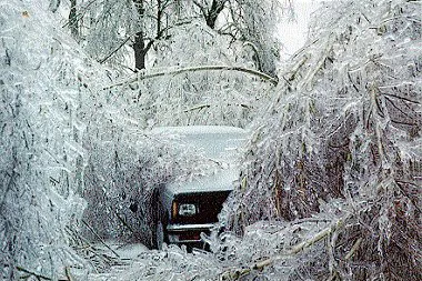
The Mid-South is currently in the grip of a historic and dangerous winter weather event as Sunday, January 25, 2026, marks the peak of a massive storm system moving through the region. Memphis residents are being urged to stay off the roads as significant ice accumulation and bitter cold temperatures create life-threatening conditions across Shelby County. Local officials and the National Weather Service have confirmed that this storm could match some of the most severe freezes in the city's history, with impacts to infrastructure and travel that may last for several days.
Morning Forecast: A Frozen Sunrise
The day began under a heavy layer of freezing rain and sleet that intensified late Saturday night. By sunrise this morning, ice accretion was already visible on trees, power lines, and overpasses throughout the Memphis metro area. Morning temperatures are hovering in the mid-teens, approximately 14°F to 18°F, which has rendered traditional road treatments largely ineffective. Forecasters indicate that the heaviest bands of freezing rain will continue to move through the area during the early morning hours, creating a glaze that is expected to thicken significantly by noon.
Afternoon Outlook: Sleet and Hazardous Travel
As we move into the afternoon, the precipitation is expected to shift toward a mix of sleet and light snow. While the rate of freezing rain may slow, the danger remains extreme as total ice accumulation is projected to reach or exceed 0.75 inches in some neighborhoods. The afternoon high temperature will struggle to reach just 20°F. High winds are also a concern, as they increase the risk of ice-laden branches snapping and falling onto power lines. Residents are advised to prepare for potential prolonged power outages as the system maintains its grip on the city.
Evening Conditions and Bitter Wind Chills
While the active precipitation is expected to taper off by the evening, the threat transitions from ice to extreme cold. The National Weather Service’s Ice Storm Warning is currently set to expire at 6:00 PM, but a secondary blast of arctic air will drive temperatures down toward a low of 4°F overnight. Wind chill values are anticipated to plunge into the single digits and even negative territory, reaching as low as -10°F. Any slush or moisture remaining on the roads will flash-freeze, ensuring that travel conditions remain treacherous well into Monday morning.
Current Alerts and Warnings
- Ice Storm Warning: In effect until 6:00 PM CST. Expect significant ice accretion of over a quarter inch and dangerous travel conditions.
- Winter Storm Warning: Remains active for the broader Mid-South, with heavy sleet and snow potential of 4 to 6 inches north of the city.
- Extreme Cold Notice: Sub-freezing temperatures are expected to persist through at least the middle of next week, requiring residents to take precautions for pipes and pets.